
Mapa topográfico County Kerry
Mapa interactivo
Haga clic en el mapa para ver la altitud.
Acerca de este mapa
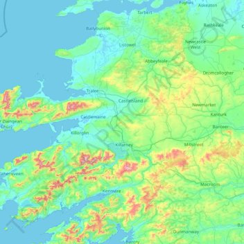
Nombre: Mapa topográfico County Kerry, altitud, relieve.
Lugar: County Kerry, Munster, Irlanda (51.68820 -10.66262 52.60245 -9.11875)
Altitud media: 123 m
Altitud mínima: -2 m
Altitud máxima: 971 m
Otros mapas topográficos
Haga clic en un mapa para ver su topografía, su altitud y su relieve.
Lough Tay
Lough Tay, Glendalough ED, The Municipal District of Wicklow, County Wicklow, Leinster, Irlanda
Altitud media: 395 m
Waste
Waste, Kilcomb ED, The Municipal District of Gorey — Kilmuckridge, Condado de Wexford, Leinster, Irlanda
Altitud media: 59 m
Carhue
Irlanda > Condado de Cork > Municipal District of Macroom
Carhue, Dripsey, Municipal District of Macroom, Condado de Cork, Munster, Irlanda
Altitud media: 138 m
Churchtown-Orwell ED
Churchtown-Orwell ED, Dublin 14, Dún Laoghaire-Rathdown, County Dublin, Leinster, Irlanda
Altitud media: 54 m
Maryborough
Maryborough, Portlaoise Rural ED, The Municipal District of Portlaoise, County Laois, Leinster, R32 KV20, Irlanda
Altitud media: 96 m