
Haz una donación
Mapa topográfico Nagarkot
Haga clic en el mapa para ver la altitud.
Haz una donación
Nagarkot
Nagarkot (Nepali: नगरकोट) is a former village development committee located 32 km east of Kathmandu, Nepal, in Bhaktapur District in Bagmati Province and as of 2015 part of Nagarkot Municipality. At the time of the 2011 census it had a population of 4,571 and had 973 houses in it. At an elevation of 2,195 meters, it is considered one of the most scenic spots in Bhaktapur District. It is known for a sunrise view of the Himalayas including Mount Everest as well as other peaks of the Himalayan range of eastern Nepal. Nagarkot also offers views of the Kathmandu Valley. The scenery of the place makes it a popular hiking route for tourists. It is located approximately 7000 ft (2000 m) above sea level and 28 km from Kathmandu International Airport.
Haz una donación
Acerca de este mapa
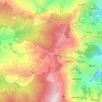
Nombre: Mapa topográfico Nagarkot, altitud, relieve.
Altitud media: 1.679 m
Altitud mínima: 1.214 m
Altitud máxima: 2.059 m
Haz una donación
Otros mapas topográficos
Haga clic en un mapa para ver su topografía, su altitud y su relieve.
Haz una donación
Haz una donación