
Haz una donación
Mapa topográfico Beaver Dam
Haga clic en el mapa para ver la altitud.
Haz una donación
Acerca de este mapa
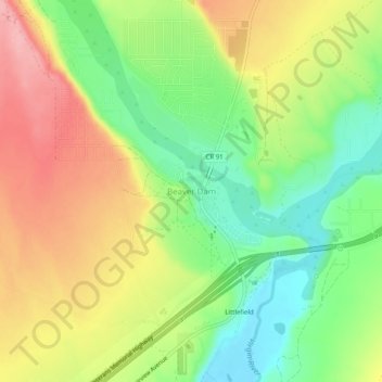
Nombre: Mapa topográfico Beaver Dam, altitud, relieve.
Lugar: Beaver Dam, Mohave County, Arizona, United States (36.87980 -113.95593 36.91980 -113.91593)
Altitud media: 596 m
Altitud mínima: 537 m
Altitud máxima: 661 m
Haz una donación
Otros mapas topográficos
Haga clic en un mapa para ver su topografía, su altitud y su relieve.
Hoover Dam
United States > Arizona > Mohave County
The amount of electricity generated by Hoover Dam has been decreasing along with the falling water level in Lake Mead due to the prolonged drought since year 2000 and high demand for the Colorado River's water. By 2014 its generating capacity was downrated by 23% to 1592 MW and was providing power only during…
Altitud media: 429 m
Kingman
United States > Arizona > Mohave County
Lt. Edward Fitzgerald Beale, a U.S. Navy officer in the service of the Army Corps of Topographical Engineers, was ordered by the U.S. War Department to build a federal wagon road across the 35th parallel. His secondary orders were to test the feasibility of the use of camels as pack animals in the Southwestern…
Altitud media: 1.131 m
Bullhead City
United States > Arizona > Mohave County
Hardyville Pioneer Cemetery, a small cemetery, now a historic landmark at 35°7′16″N 114°35′17″W / 35.12111°N 114.58806°W / 35.12111; -114.58806, is the most significant existing remnant of Hardyville. An unofficial historical marker for the town is in the parking lot across Highway 95 from…
Altitud media: 328 m
Haz una donación
Antares
United States > Arizona > Mohave County > Antares
Antares is located in northwestern Arizona, in central Mohave County, 21 miles (34 km) northeast of Kingman, the county seat. The Antares census-designated place encompasses 0.65 square miles (1.7 km2) of land, and is at 3,556 feet (1,084 m) elevation above sea level. The southern edge of the CDP follows State…
Altitud media: 1.060 m
Haz una donación
Hoover Dam
United States > Arizona > Mohave County
The amount of electricity generated by Hoover Dam has been decreasing along with the falling water level in Lake Mead due to the prolonged drought since year 2000 and high demand for the Colorado River's water. By 2014 its generating capacity was downrated by 23% to 1592 MW and was providing power only during…
Altitud media: 429 m
Kingman
United States > Arizona > Mohave County
Lt. Edward Fitzgerald Beale, a U.S. Navy officer in the service of the Army Corps of Topographical Engineers, was ordered by the U.S. War Department to build a federal wagon road across the 35th parallel. His secondary orders were to test the feasibility of the use of camels as pack animals in the Southwestern…
Altitud media: 1.131 m
Haz una donación
Haz una donación
Bullhead City
United States > Arizona > Mohave County
Hardyville Pioneer Cemetery, a small cemetery, now a historic landmark at 35°7′16″N 114°35′17″W / 35.12111°N 114.58806°W / 35.12111; -114.58806, is the most significant existing remnant of Hardyville. An unofficial historical marker for the town is in the parking lot across Highway 95 from…
Altitud media: 322 m
Bullhead City
United States > Arizona > Mohave County
Hardyville Pioneer Cemetery, a small cemetery, now a historic landmark at 35°7′16″N 114°35′17″W / 35.12111°N 114.58806°W / 35.12111; -114.58806, is the most significant existing remnant of Hardyville. An unofficial historical marker for the town is in the parking lot across Highway 95 from…
Altitud media: 328 m
Haz una donación
Kingman
United States > Arizona > Mohave County
Lt. Edward Fitzgerald Beale, a U.S. Navy officer in the service of the Army Corps of Topographical Engineers, was ordered by the U.S. War Department to build a federal wagon road across the 35th parallel. His secondary orders were to test the feasibility of the use of camels as pack animals in the Southwestern…
Altitud media: 1.130 m
Hoover Dam
United States > Arizona > Mohave County
The amount of electricity generated by Hoover Dam has been decreasing along with the falling water level in Lake Mead due to the prolonged drought in the 2010s and high demand for the Colorado River's water. Lake Mead fell to a new record low elevation of 1,071.61 feet (326.63 m) on July 1, 2016 before…
Altitud media: 429 m
Haz una donación
Kingman
United States > Arizona > Mohave County > Kingman
Lt. Edward Fitzgerald Beale, a U.S. Navy officer in the service of the U.S. Army Corps of Topographical Engineers, was ordered by the U.S. War Department to build a federal wagon road across the 35th Parallel. His secondary orders were to test the feasibility of the use of camels as pack animals in the…
Altitud media: 1.135 m
Haz una donación