
Haz una donación
Mapa topográfico Atia
Haga clic en el mapa para ver la altitud.
Haz una donación
Acerca de este mapa
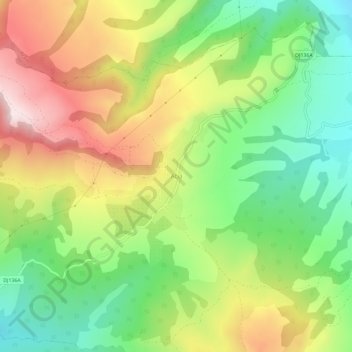
Nombre: Mapa topográfico Atia, altitud, relieve.
Lugar: Atia, Corund, Harghita, 537061, Romania (46.46677 25.10963 46.50677 25.14963)
Altitud media: 715 m
Altitud mínima: 514 m
Altitud máxima: 977 m
Haz una donación
Otros mapas topográficos
Haga clic en un mapa para ver su topografía, su altitud y su relieve.
Haz una donación
Haz una donación
Haz una donación
Băile Tușnad
With a population of 1,372 (as of 2021), it is the smallest town in Romania by population. It is located at an altitude of 650 m (2,130 ft) in the southern reaches of the Ciuc depression, between the Harghita and Bodoc mountains, in the valley of the Olt River, and is to this day an important spa town. The…
Altitud media: 882 m
Haz una donación
Haz una donación
Băile Tușnad
With a population of 1,617, it is the smallest town in Romania by population. It is located at an altitude of 650 metres in the southern reaches of the Ciuc depression, between the Harghita and Bodoc mountains, in the valley of the Olt, and is to this day an important spa town. The town administers one…
Altitud media: 833 m
Borsec
Borsec, a resort chiefly known for its mineral water and favourable climate, is situated in the intracarpatic depression of the same name, at an altitude of 900 m (3,000 ft). The Borsec Depression has an oval shape and is northeast oriented, being separated from the hilltop of the Rotunda Chair in two…
Altitud media: 1.053 m
Haz una donación