
Gracias por apoyar a este sitio ❤️
Haz una donación
Haz una donación
Mapa topográfico Diktel
Haga clic en el mapa para ver la altitud.
Gracias por apoyar a este sitio ❤️
Haz una donación
Haz una donación
Diktel
Diktel was renamed to Rupakot Majhuwagadhi on 10 March 2017 after merging some more VDCs. The municipality is divided into 15 wards. It is on 700 m to 2250 m of elevation from sea level. The area of the municipality is 246.51 km2. There are 10,050 households with population of 46,903. By 2020, the name commonly used name Diktel was re-added to the municipality's official name.
Gracias por apoyar a este sitio ❤️
Haz una donación
Haz una donación
Acerca de este mapa
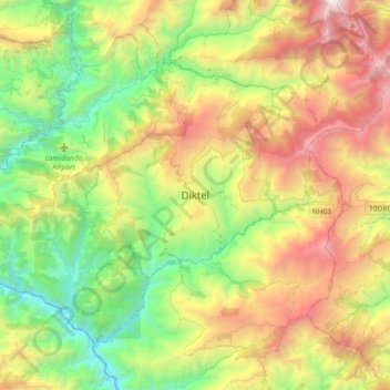
Nombre: Mapa topográfico Diktel, altitud, relieve.
Lugar: Diktel, Rupakot Majhuwagadhi, Khotang, Koshi Province, Nepal (27.05328 86.63318 27.37328 86.95318)
Altitud media: 1.505 m
Altitud mínima: 252 m
Altitud máxima: 3.602 m
Gracias por apoyar a este sitio ❤️
Haz una donación
Haz una donación
Otros mapas topográficos
Haga clic en un mapa para ver su topografía, su altitud y su relieve.