
Gracias por apoyar a este sitio ❤️
Haz una donación
Haz una donación
Mapa topográfico Taplejung
Haga clic en el mapa para ver la altitud.
Gracias por apoyar a este sitio ❤️
Haz una donación
Haz una donación
Taplejung
Geographically Taplejung is a mountainous district where the world's third highest peak Kanchenjunga (8586 m) is located. It is situated at elevation ranging from 670 metres (2,200 ft) to 8,586 metres (28,169 ft) from sea level.
Gracias por apoyar a este sitio ❤️
Haz una donación
Haz una donación
Acerca de este mapa
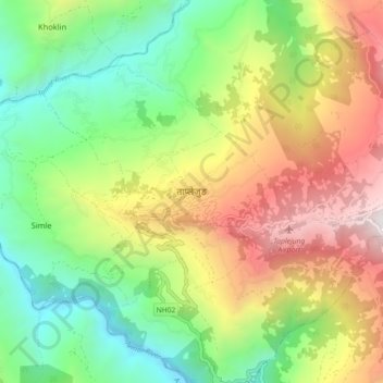
Nombre: Mapa topográfico Taplejung, altitud, relieve.
Lugar: Taplejung, Phungling, Taplejung, Koshi Province, 57500, Nepal (27.31870 87.63273 27.39870 87.71273)
Altitud media: 1.410 m
Altitud mínima: 556 m
Altitud máxima: 2.666 m
Gracias por apoyar a este sitio ❤️
Haz una donación
Haz una donación
Otros mapas topográficos
Haga clic en un mapa para ver su topografía, su altitud y su relieve.