
Haz una donación
Mapa topográfico Poduri
Haga clic en el mapa para ver la altitud.
Haz una donación
Acerca de este mapa
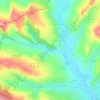
Nombre: Mapa topográfico Poduri, altitud, relieve.
Lugar: Poduri, Valea Largă, Mureș, 547618, Romania (46.61458 24.04107 46.65458 24.08107)
Altitud media: 349 m
Altitud mínima: 295 m
Altitud máxima: 438 m
Haz una donación
Otros mapas topográficos
Haga clic en un mapa para ver su topografía, su altitud y su relieve.
Bichiș
The commune is situated on the Transylvanian Plateau, at an altitude of 338 m (1,109 ft), on the banks of the river Ațintiș. It is located in the southwestern part of Mureș County, 16 km (10 mi) south of the town of Luduș and 53 km (33 mi) from the county seat, Târgu Mureș, on the border with Alba County.
Altitud media: 395 m
Haz una donación
Haz una donación
Haz una donación
Haz una donación
Haz una donación
Târgu Mureș
The old City Hall was built in 1906–1907 after the construction plans of Márcell Komor and Dezső Jakab. The entrance area, including the corridor and the staircase leading to the first floor, is the most representative in this regard. The ribbed stellar vaults that cover this area were inspired by Gothic…
Altitud media: 357 m
Haz una donación
Haz una donación
Haz una donación