
Haz una donación
Mapa topográfico Tahoma
Haga clic en el mapa para ver la altitud.
Haz una donación
Acerca de este mapa
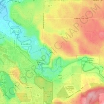
Nombre: Mapa topográfico Tahoma, altitud, relieve.
Lugar: Tahoma, King County, Washington, 98038, United States (47.36816 -122.03150 47.40816 -121.99150)
Altitud media: 173 m
Altitud mínima: 95 m
Altitud máxima: 250 m
Haz una donación
Otros mapas topográficos
Haga clic en un mapa para ver su topografía, su altitud y su relieve.
Haz una donación
Lake Marcel
United States > Washington > King County
Lake Marcel is at an altitude of 295 feet (90 m) above sea level. The lake sits in a bowl at the top of Stillwater Hill on the east side of the Snoqualmie Valley, north of Carnation. It has two main areas of water connected by a channel, and several peninsular features make an extensive shoreline around the…
Altitud media: 110 m
Haz una donación
Haz una donación
Haz una donación
Clyde Hill
United States > Washington > King County
The top elevation is close to 375 feet. There are approximately 21 miles of public roadways in Clyde Hill.
Altitud media: 48 m
Haz una donación
Snoqualmie River
United States > Washington > King County
The Middle Fork Valley is a popular recreational area since it is accessible during the winter due to its low altitude and close proximity to Seattle. For many years the Middle Fork Road extended 24 miles to Hardscrabble Creek, but was gated at Dingford Creek in June 2007, 18 miles in. The gate at Dingford…
Altitud media: 212 m
Haz una donación
Mercer Island
United States > Washington > King County > Mercer Island
Mercer Island City Hall is located at 47°34′39″N 122°12′43.2″W / 47.57750°N 122.212000°W / 47.57750; -122.212000 (47.5775, -122.212). The peak elevation in the city is about 338 feet (103 m), near the center of the island.
Altitud media: 39 m
Haz una donación
Donnie Chin International Children’s Park
United States > Washington > King County > Seattle
Altitud media: 43 m
Haz una donación
West Tiger Mountain Natural Resource Conservation Area
United States > Washington > King County > Issaquah
Altitud media: 101 m