
Haz una donación
Mapa topográfico Tengboche
Haga clic en el mapa para ver la altitud.
Haz una donación
Tengboche
Tengboche is located on a hill at the confluence of the Dudh Kosi and the Imja Khola rivers. It lies in Solukhumbu district to the north east of Kathmandu on the Nepal – Tibet border. It is inhabited by sherpas ('sherpa' literally means the easterner) who migrated from Tibet six hundred years ago. It is approached by a mountain trail from Namche, the nearest airport in Lukla (2,800 metres (9,200 ft)) connecting to Kathmandu. It is about two days of trekking from Lukla. However, considering acclimatization needs for the high altitude climbing, a four-day trekking is generally preferred. This trail crosses initially the Dudh Kosi (3,250 metres (10,660 ft)) river and a further climb leads to the Tengboche monastery at 3,870 metres (12,700 ft) altitude. However, a down hill trek leads to Devouche, the nunnery. During the winter, the snow peaks of Ama Dablam, the tip of the Everest that glows from the Nuptse ridge and several other peaks form a picturesque landscape.
Haz una donación
Acerca de este mapa
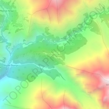
Nombre: Mapa topográfico Tengboche, altitud, relieve.
Altitud media: 3.936 m
Altitud mínima: 3.215 m
Altitud máxima: 4.970 m
Haz una donación
Otros mapas topográficos
Haga clic en un mapa para ver su topografía, su altitud y su relieve.