
Haz una donación
Mapa topográfico Ajo
Haga clic en el mapa para ver la altitud.
Haz una donación
Acerca de este mapa
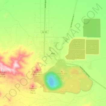
Nombre: Mapa topográfico Ajo, altitud, relieve.
Lugar: Ajo, Pima County, Arizona, 85321, United States (32.33719 -112.90457 32.41719 -112.82457)
Altitud media: 547 m
Altitud mínima: 274 m
Altitud máxima: 896 m
Haz una donación
Otros mapas topográficos
Haga clic en un mapa para ver su topografía, su altitud y su relieve.
Tucson
United States > Arizona > Pima County
Tucson is situated on an alluvial plain in the Sonoran Desert, at an elevation of approximately 2,400 feet (730 meters) above sea level. The city is enveloped by five mountain ranges, which contribute significantly to its varied topography. To the north lie the Santa Catalina and Tortolita Mountains, while the…
Altitud media: 822 m
Tucson
United States > Arizona > Pima County
By 1900, 7,531 people lived in Tucson. By 1910, the population increased to 13,913. At about this time, the U.S. Veterans Administration had begun construction of the present Veterans Hospital. The city's clean, dry air made it a destination for the many veterans who had been gassed in World War I and needed…
Altitud media: 822 m
Oro Valley
United States > Arizona > Pima County
Oro Valley is located at 32°25′N 110°59′W / 32.417°N 110.983°W / 32.417; -110.983 (32.4212, −110.9760) in the middle Cañada del Oro Valley. Oro Valley sits at an average elevation of 2,620 feet (800 m) above sea level.
Altitud media: 969 m
Haz una donación
Marana
United States > Arizona > Pima County
Marana has a hot semi-arid climate (Köppen climate classification BSh). This is characterized by hot summers and relatively mild winters. The area averages only 12.19 inches (310 mm) of annual rainfall. During the dry and sunny winter months, daytime highs usually reach between 60°F and 70°F (16°C and…
Altitud media: 660 m
Haz una donación
Catalina State Park
United States > Arizona > Pima County
Catalina State Park is located at the base of the Santa Catalina Mountains. It is home to nearly 5,000 saguaros and desert plants. There are 5,500 acres of foothills and canyons that offer opportunities for camping, hiking, and bird watching. The park is home to more than 150 species. At an elevation of nearly…
Altitud media: 906 m
Haz una donación
Saguaro National Park
United States > Arizona > Pima County
Both districts conserve tracts of the Sonoran Desert, including ranges of significant hills, the Tucson Mountains in the west and the Rincon Mountains in the east. Elevations in the Tucson Mountain District range from 2,180 to 4,687 feet (664 to 1,429 m), the summit of Wasson Peak. Elevations within the Rincon…
Altitud media: 1.174 m
Marana
United States > Arizona > Pima County
Marana has a hot semi-arid climate (Köppen climate classification BSh). This is characterized by hot summers and relatively mild winters. The area averages only 12.19 inches (310 mm) of annual rainfall. During the dry and sunny winter months, daytime highs usually reach between 60°F and 70°F (16°C and…
Altitud media: 657 m
Haz una donación
Saguaro National Park
United States > Arizona > Pima County
Both districts conserve tracts of the Sonoran Desert, including ranges of significant hills, the Tucson Mountains in the west and the Rincon Mountains in the east. Elevations in the Tucson Mountain District range from 2,180 to 4,687 feet (664 to 1,429 m), the summit of Wasson Peak. Elevations within the Rincon…
Altitud media: 1.174 m
Haz una donación
Marana
United States > Arizona > Pima County
Marana has a hot semi-arid climate (Köppen climate classification BSh). This is characterized by hot summers and relatively mild winters. The area averages only 12.19 inches (310 mm) of annual rainfall. During the dry and sunny winter months, daytime highs usually reach between 60 and 70 °F (16 and 21 °C),…
Altitud media: 660 m
Oro Valley
United States > Arizona > Pima County
Oro Valley is located at 32°25′N 110°59′W / 32.417°N 110.983°W / 32.417; -110.983 (32.4212, −110.9760) in the middle of the Cañada del Oro Valley. Oro Valley sits at an average elevation of 2,620 feet (800 m) above sea level.
Altitud media: 969 m
Haz una donación
Tucson
United States > Arizona > Pima County
By 1900, Tucson had 7,531 residents. By 1910, the population increased to 13,913. About this time, the U.S. Veterans Administration had begun construction of the present Veterans Hospital. The city's clean, dry air made it a destination for many veterans who had been gassed in World War I and needed…
Altitud media: 822 m
Tucson
United States > Arizona > Pima County
By 1900, 7,531 people lived in Tucson. By 1910, the population increased to 13,913. About this time, the U.S. Veterans Administration had begun construction of the present Veterans Hospital. The city's clean, dry air made it a destination for many veterans who had been gassed in World War I and needed…
Altitud media: 822 m
Saguaro National Park
United States > Arizona > Pima County
Both districts conserve tracts of the Sonoran Desert, including ranges of significant hills, the Tucson Mountains in the west and the Rincon Mountains in the east. Elevations in the Tucson Mountain District range from 2,180 to 4,687 feet (664 to 1,429 m), the summit of Wasson Peak. Elevations within the Rincon…
Altitud media: 1.174 m
Haz una donación
Oro Valley
United States > Arizona > Pima County
Oro Valley is located at 32°25′N 110°59′W / 32.417°N 110.983°W / 32.417; -110.983 (32.4212, −110.9760) in the middle of the Cañada del Oro Valley. Oro Valley sits at an average elevation of 2,620 feet (800 m) above sea level.
Altitud media: 969 m
Haz una donación
Saguaro National Park
United States > Arizona > Pima County
Both districts conserve tracts of the Sonoran Desert, including ranges of significant hills, the Tucson Mountains in the west and the Rincon Mountains in the east. Elevations in the Tucson Mountain District range from 2,180 to 4,687 feet (664 to 1,429 m), the summit of Wasson Peak. Elevations within the Rincon…
Altitud media: 1.174 m
Haz una donación
Tucson
United States > Arizona > Pima County
By 1900, 7,531 people lived in Tucson. By 1910, the population increased to 13,913. About this time, the U.S. Veterans Administration had begun construction of the present Veterans Hospital. The city's clean, dry air made it a destination for many veterans who had been gassed in World War I and needed…
Altitud media: 822 m
Oro Valley
United States > Arizona > Pima County
Oro Valley is located at 32°25′N 110°59′W / 32.417°N 110.983°W / 32.417; -110.983 (32.4212, −110.9760) in the middle Cañada del Oro Valley. Oro Valley sits at an average elevation of 2,620 feet (800 m) above sea level.
Altitud media: 969 m
Haz una donación