
Haz una donación
Mapa topográfico Avalon Peninsula
Haga clic en el mapa para ver la altitud.
Haz una donación
Acerca de este mapa
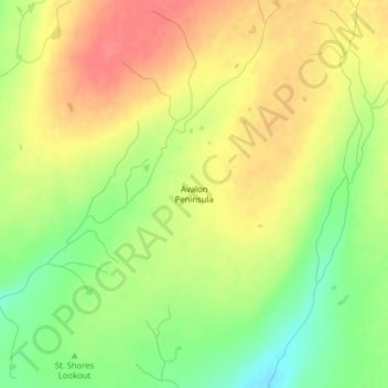
Nombre: Mapa topográfico Avalon Peninsula, altitud, relieve.
Altitud media: 116 m
Altitud mínima: 82 m
Altitud máxima: 143 m
Haz una donación
Otros mapas topográficos
Haga clic en un mapa para ver su topografía, su altitud y su relieve.
Haz una donación
Terra Nova National Park
Canada > Newfoundland and Labrador
Terra Nova's landscape is typical of the northeast coast of Newfoundland, but with remnants of the Appalachian Mountains contributing to widely varied and rugged topography throughout the region. The park's seacoast consists of several rocky "fingers" jutting into Bonavista Bay along an area stretching from…
Altitud media: 58 m
Haz una donación
Haz una donación
Clarenville
Canada > Newfoundland and Labrador
The Clarenville area has many of the physical features characteristic of the East Coast of Newfoundland and has a marine climate. It lies along the coastal slopes which rise from the Atlantic Ocean towards the interior central plateau of the island. The dominating physical feature is a ridge of broken peaks…
Altitud media: 102 m
Haz una donación
Haz una donación
Haz una donación
Haz una donación
Haz una donación
Haz una donación
Haz una donación
Haz una donación
Haz una donación
Haz una donación
Memorial University of Newfoundland main campus
Canada > Newfoundland and Labrador > St. John's
Altitud media: 78 m
Haz una donación
Haz una donación
Haz una donación
Pistolet Bay Provincial Park
Canada > Newfoundland and Labrador > unincorporated Newfoundland
Altitud media: 21 m
Pistolet Bay Provincial Park
Canada > Newfoundland and Labrador > unincorporated Newfoundland
Altitud media: 21 m
Haz una donación
Haz una donación
Haz una donación
Haz una donación
Haz una donación
Haz una donación
Haz una donación
Haz una donación
Haz una donación