
Gracias por apoyar a este sitio ❤️
Haz una donación
Haz una donación
Mapa topográfico Rânca
Haga clic en el mapa para ver la altitud.
Gracias por apoyar a este sitio ❤️
Haz una donación
Haz una donación
Acerca de este mapa
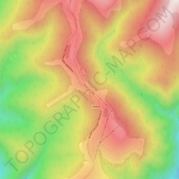
Nombre: Mapa topográfico Rânca, altitud, relieve.
Lugar: Rânca, Baia de Fier, Gorj, Romania (45.27211 23.66891 45.31211 23.70891)
Altitud media: 1.472 m
Altitud mínima: 1.016 m
Altitud máxima: 1.831 m
Gracias por apoyar a este sitio ❤️
Haz una donación
Haz una donación
Otros mapas topográficos
Haga clic en un mapa para ver su topografía, su altitud y su relieve.
Gracias por apoyar a este sitio ❤️
Haz una donación
Haz una donación
Gracias por apoyar a este sitio ❤️
Haz una donación
Haz una donación
Novaci
Only 12 km (7.5 mi) from Novaci, passing the Transalpina (DN67C) road is Rânca (1,600 m (5,200 ft) altitude), a newly developed resort surrounded by mountain peaks and tremendous beauty. From this place is a view of the Parângu Mare peak and when the weather is good you can see the Peleaga peak of the…
Altitud media: 1.056 m
Gracias por apoyar a este sitio ❤️
Haz una donación
Haz una donación
Gracias por apoyar a este sitio ❤️
Haz una donación
Haz una donación