
Haz una donación
Mapa topográfico Fort Collins
Haga clic en el mapa para ver la altitud.
Haz una donación
Acerca de este mapa
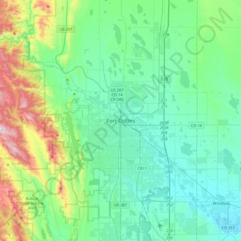
Nombre: Mapa topográfico Fort Collins, altitud, relieve.
Altitud media: 1.644 m
Altitud mínima: 1.443 m
Altitud máxima: 2.401 m
Haz una donación
Otros mapas topográficos
Haga clic en un mapa para ver su topografía, su altitud y su relieve.
Rocky Mountain National Park
United States > Colorado > Larimer County
Rocky Mountain National Park is one of the highest national parks in the nation, with elevations from 7,860 to 14,259 feet (2,396 to 4,346 m), the highest point of which is Longs Peak. Trail Ridge Road is the highest paved through-road in the country, with a peak elevation of 12,183 feet (3,713 m). Sixty…
Altitud media: 3.073 m
Estes Park
United States > Colorado > Larimer County
Estes Park sits at an elevation of 7,522 feet (2,293 m) on the front range of the Rocky Mountains at the eastern entrance of the Rocky Mountain National Park. Its location is 40°22′22″N 105°31′09″W / 40.372856°N 105.519136°W / 40.372856; -105.519136. Its north, south and east extremities…
Altitud media: 2.421 m