
Gracias por apoyar a este sitio ❤️
Haz una donación
Haz una donación
Mapa topográfico Aburi
Haga clic en el mapa para ver la altitud.
Gracias por apoyar a este sitio ❤️
Haz una donación
Haz una donación
Aburi
Due to the altitude of Aburi, the climate is a lot cooler than neighbouring Accra. The road which climbs the hillside to Aburi is a toll road, with the current toll being 0.50 Ghc for a car, 1.00 Ghc for a 4x4.
Gracias por apoyar a este sitio ❤️
Haz una donación
Haz una donación
Acerca de este mapa
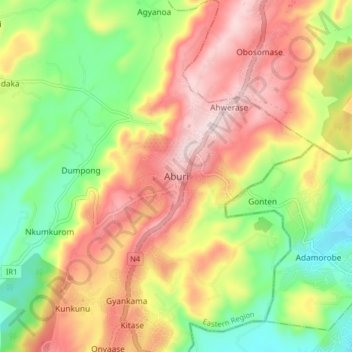
Nombre: Mapa topográfico Aburi, altitud, relieve.
Lugar: Aburi, Akuapim South District, Eastern Region, Ghana (5.80748 -0.21527 5.88748 -0.13527)
Altitud media: 277 m
Altitud mínima: 88 m
Altitud máxima: 478 m
Gracias por apoyar a este sitio ❤️
Haz una donación
Haz una donación