Geolocalizar

Mapa topográfico Cozla

Haga clic en el mapa para ver la altitud.

Acerca de este mapa

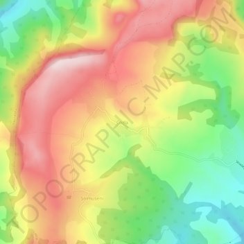
Nombre: Mapa topográfico Cozla, altitud, relieve.

Lugar: Cozla, Letca, Sălaj, 457217, Romania (47.32843 23.36486 47.36843 23.40486)

Altitud media: 417 m

Altitud mínima: 240 m

Altitud máxima: 580 m

Otros mapas topográficos

Haga clic en un mapa para ver su topografía, su altitud y su relieve.

Camăr

Romania > Sălaj

Altitud media: 251 m

Treznea

Romania > Sălaj

The commune is situated in the foothills of the Meseș Mountains, at an altitude of 304 m (997 ft), on the banks of the river Treznea. It is located in the central-south part of Sălaj County, at a distance of 14 km (8.7 mi) from the county seat, Zalău.

Altitud media: 385 m

Hereclean

Romania > Sălaj

Altitud media: 267 m

Halmășd

Romania > Sălaj

Altitud media: 382 m

Marca

Romania > Sălaj

Altitud media: 244 m

Zalău

Romania > Sălaj

The city includes a total surface of 90.09 km2 (34.78 sq mi). This includes the one village it administers, Stâna (Felsőnyárló), situated south-east of Meseș, in the hydrographic basin of the Agrij River. Măgura Stânii is at an altitude of 716 m (2,349 ft).

Altitud media: 317 m

Meseșenii de Jos

Romania > Sălaj

Altitud media: 335 m

Almașu

Romania > Sălaj

Altitud media: 433 m

Bic

Romania > Sălaj

Altitud media: 318 m

Lozna

Romania > Sălaj

Altitud media: 233 m

Românași

Romania > Sălaj > Românași

Altitud media: 275 m

Romita

Romania > Sălaj > Romita

Altitud media: 264 m

Tihău

Romania > Sălaj > Tihău

Altitud media: 240 m

Pria

Romania > Sălaj > Pria

Altitud media: 432 m

Zalău

Romania > Sălaj

The city includes a total surface of 90.09 km2 (34.78 sq mi). This includes the one village it administers, Stâna (Felsőnyárló), situated south-east of Meseș, in the hydrographic basin of the Agrij River. Măgura Stânii is at an altitude of 716 m (2,349 ft).

Altitud media: 346 m

Sutoru

Romania > Sălaj > Sutoru

Altitud media: 321 m

Ilișua

Romania > Sălaj > Ilișua

Altitud media: 235 m