
Mapa topográfico South Andaman Island
Mapa interactivo
Haga clic en el mapa para ver la altitud.
Acerca de este mapa
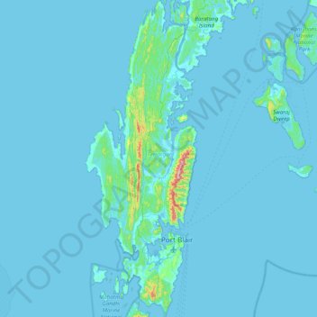
Nombre: Mapa topográfico South Andaman Island, altitud, relieve.
Altitud media: 13 m
Altitud mínima: -2 m
Altitud máxima: 444 m
Otros mapas topográficos
Haga clic en un mapa para ver su topografía, su altitud y su relieve.
South Andaman
India > Andaman and Nicobar Islands
South Andaman, Andaman and Nicobar Islands, India
Altitud media: 3 m
South Brother Island
India > Andaman and Nicobar Islands
South Brother Island, South Andaman, Andaman and Nicobar Islands, India
Altitud media: 1 m