
Gracias por apoyar a este sitio ❤️
Haz una donación
Haz una donación
Mapa topográfico Pahalgam
Haga clic en el mapa para ver la altitud.
Gracias por apoyar a este sitio ❤️
Haz una donación
Haz una donación
Pahalgam
Pahalgam (Urdu pronunciation: [pɛɦɛlɡɑːm]) or Pahalgom (Kashmiri pronunciation: [pəhəlʲɡoːm]) is a town in Anantnag district of the Indian union territory of Jammu and Kashmir. It is located on the banks of Lidder River at an altitude of 2,200 m (7,200 ft) in the Vale of Kashmir. Pahalgam is the headquarters of the Pahalgam tehsil, one of the eleven tehsils in Anantnag district.
Gracias por apoyar a este sitio ❤️
Haz una donación
Haz una donación
Acerca de este mapa
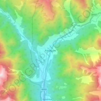
Nombre: Mapa topográfico Pahalgam, altitud, relieve.
Lugar: Pahalgam, Anantnag, Jammu and Kashmir, 192126, India (33.99220 75.28265 34.07220 75.36265)
Altitud media: 2.700 m
Altitud mínima: 2.082 m
Altitud máxima: 3.909 m
Gracias por apoyar a este sitio ❤️
Haz una donación
Haz una donación