
Haz una donación
Mapa topográfico Rod
Haga clic en el mapa para ver la altitud.
Haz una donación
Acerca de este mapa
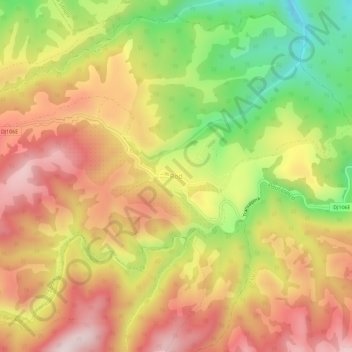
Nombre: Mapa topográfico Rod, altitud, relieve.
Lugar: Rod, Tilișca, Sibiu, 557281, Romania (45.78155 23.76177 45.82155 23.80177)
Altitud media: 794 m
Altitud mínima: 531 m
Altitud máxima: 1.008 m
Haz una donación
Otros mapas topográficos
Haga clic en un mapa para ver su topografía, su altitud y su relieve.
Haz una donación
Haz una donación
Haz una donación
Haz una donación
Bâlea Lake
Romania > Sibiu > Cârțișoara
Bâlea Lake (Romanian: Lacul Bâlea or Bâlea Lac, pronounced [ˈbɨle̯a]; Hungarian: Bilea-tó) is a glacier lake situated at 2,034 m of altitude in the Făgăraș Mountains, in central Romania, in Cârțișoara, Sibiu County. There are two chalets opened all the year round, a meteorological station and a…
Altitud media: 2.080 m
Racovița
Racovița Commune is situated at the base of Suru Peak (2,281 m or 7,484 ft) on the contact between the foothills of the Făgăraș Mountains and the low terrace of the floodplain, on the left bank of the river Olt, at an altitude of 385 meters. The commune borders to the north and northeast with the town…
Altitud media: 674 m
Haz una donación
Haz una donación
Haz una donación